Your China & Yunnan Travel Experts



China's historic bridges solved very different problems: tidal estuaries, inland rivers, military approaches and commercial crossings. The four examples below are a representative travel selection, not an official ranking. Together they show stone beams, an open-spandrel arch, a combined fixed-and-floating structure and a multi-arch bridge.
Read each bridge as infrastructure and cultural landscape. Piers, arches, paving, inscriptions and later repairs reveal how the crossing worked. The ancient Chinese architecture guide provides wider construction context, while the longest bridges in China guide explains why modern engineering belongs to a separate comparison.
How to read a historic bridge
Begin with the obstacle: river width, current, flood level, tide, navigation and ground conditions. Then identify the structural system—beam, arch, pontoon or a combination—and how loads reach the piers and foundations. A bridge that looks simple may embody difficult quarrying, transport, cofferdam or maintenance work.
Next separate the first construction from the bridge now visible. Flood, warfare, traffic and aging led to repairs. A name can continue even when deck stones, pavilions or balustrades are later. Good interpretation gives the earliest documented phase, major rebuilding and current conservation condition instead of calling every component “original.”
Finally, view the crossing as public space. Markets, processions, defense, tolls, shrines and local memory can be as important as span length. Check whether vehicles, bicycles or ceremonies still use the bridge, and do not block a working route for photographs.
Luoyang Bridge, Quanzhou
Built across the Luoyang River estuary in the Northern Song period under the administration of Cai Xiang, Luoyang Bridge used stone piers and large stone slabs in a difficult tidal environment. Ship-shaped pier ends helped divide the current, and oyster cultivation became associated with consolidating parts of the stonework.
The bridge belongs to Quanzhou's wider maritime heritage landscape. Do not evaluate it only by its present length: silting, repairs and altered shorelines have changed the setting. A visit is most useful when paired with the port city's temples, inscriptions and trading history.
At the estuary, look for elongated pier shapes and the way multiple stone beams form the deck. The oyster story is often repeated because biological growth could help bind stones, but labels should distinguish documented maintenance practice from simplified legend. Tide and modern water conditions affect what can be seen.
Use the current pedestrian approach and remain off exposed foundations. Wet stone and tidal edges are slippery, and a low-water photograph is not permission to enter the channel. Quanzhou's maritime museums and religious sites help explain why this regional crossing mattered to movement and exchange.
Anji Bridge, or Zhaozhou Bridge
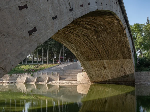
This Sui-period stone bridge in Zhao County, Hebei, is traditionally attributed to the craftsman Li Chun. Its broad segmental arch has smaller openings in the spandrels, reducing weight and allowing floodwater to pass. The design is significant because engineering efficiency and a low, graceful profile are achieved together.
The bridge has undergone repairs, so “original” should be used carefully. Study the curve, spandrel openings and stone joints from permitted viewpoints rather than relying on superlatives.
The large arch is a segment of a circle rather than a tall semicircle. That lowers the roadway while creating horizontal thrust that the abutments must resist. The small spandrel arches remove masonry weight and give floodwater additional paths. These features should be understood as a system, not as isolated decorations.
Compare the upstream and downstream faces, repairs and deck profile where access allows. Do not climb the parapet or step into a road for a centered photograph. Museum models or measured drawings can reveal construction more safely than trying to inspect every joint at close range.
Guangji Bridge, Chaozhou
Guangji Bridge crosses the Han River and developed through a long sequence of Song and later construction. Its best-known feature is the combination of fixed stone-pier sections with a central floating section formed by boats. The movable section allowed navigation and responded to river conditions, while pavilions on the piers made the bridge part of urban commercial life.
The operating arrangement, opening times and access rules can change. Confirm local information rather than assuming the floating span will be in one fixed position during a visit.
The bridge's identity comes from this combination of permanent piers and a navigable opening, as well as the line of pavilion-like structures along the crossing. River management and modern visitor operations determine how the movable section works today. Ask whether a scheduled opening can be observed and from which bank without obstructing staff.
Chaozhou's old city, riverfront and evening lighting can be combined on foot, but crowd levels and weather change the experience. Keep children away from low edges, follow closures during high water and treat commercial stalls as part of the living bridge rather than evidence that the monument lacks historical value.
Lugou Bridge, or Marco Polo Bridge
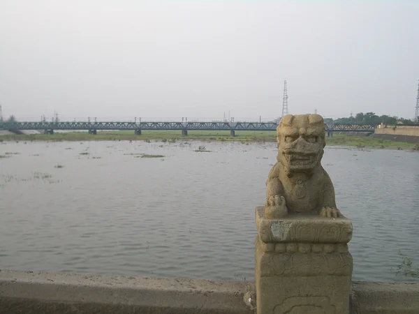
Lugou Bridge crosses the Yongding River southwest of central Beijing. Its stone arches and balustrade are famous for carved lions whose poses and dates vary. The bridge was first built in the Jin dynasty and repaired repeatedly; the present monument therefore records more than one construction phase.
The Marco Polo Bridge Incident of 7 July 1937 made the site central to the history of the Second Sino-Japanese War. Visit with both architectural and historical context, and treat nearby memorial spaces respectfully.
Travelers interested in how bridges fit a lived historic landscape can also compare the villages and waterways included in a Huangshan and Huizhou culture itinerary.
The carved lions attract attention, but the bridge's arches, paving, nearby fortress and river setting are equally important. Lion counts vary in popular accounts because small carvings, replacements and nested figures can be classified differently. Use the site's current interpretation rather than promising an exact number as a game.
Access and respectful interpretation: The bridge and nearby memorial landscape connect architecture with the outbreak of full-scale war between China and Japan in 1937. Avoid playful poses that ignore that history, and give school or family groups time to read the memorial material. Security zones, opening hours and transport from central Beijing can change.
Historic stone is uneven and can be hot, icy or slippery by season. Ask about step-free entry, rest points and accessible toilets. If photography is important, use the permitted riverbank view as well as the deck; it shows the full sequence of arches without crowding the balustrade.
Editorial accountability
Hu Lei, CEO. The named owner is responsible for travel-planning accuracy and escalation of time-sensitive checks.
Yuntian Travel (Yunnan) Group is identified in its corporate profile as a licensed professional inbound travel service provider based in Kunming, China. Registration and travel-service documents can be requested before booking.
Page-specific references where cited, official destination, transport and entry notices, YUNSKY route-planning records, and direct provider confirmation before a booking is finalized.
Content is reviewed when rules, transport, access, pricing or route conditions change. Final availability and operating details are reconfirmed for each traveler’s dates.
Quality review: Page updated: