Your China & Yunnan Travel Experts



China's largest provincial-level regions are ranked here by administrative land area, not by population, economic output or the amount of inhabited land. China covers about 9.6 million square kilometres, but published area totals can differ slightly with survey date, mapping convention and the treatment of water or boundary data. This guide therefore uses rounded figures and identifies the source-method issue where it materially affects a number.
What “province” means in this ranking
In casual travel English, “province” is often used as shorthand for any first-level region. China's formal provincial-level divisions include 23 provinces, five autonomous regions, four municipalities and two special administrative regions. This top ten consists of six provinces and four autonomous regions; municipalities and special administrative regions are smaller by administrative area.
Regional starting points: Xinjiang overview and Xinjiang travel information, Tibet, Inner Mongolia and Guangxi. Provincial-level municipalities include Beijing and Tianjin. The administrative-division map explains the categories; city guides cover Shanghai and Chongqing, while separate entry contexts apply to Hong Kong and Macao.
Method and scope
The figures below come from national or provincial government sources and are rounded to avoid false precision. Administrative land area does not mean that every square kilometre is accessible, inhabited or suitable for a visitor route. It also does not predict travel time: mountain passes, plateaus, deserts, seasonal weather and the road or rail network matter more than a region's outline. The order is stable from Xinjiang in first place to Hunan in tenth. Gansu remains seventh, although provincial documents publish different totals under different statistical conventions; the Gansu section records that range instead of hiding it.
How to read the map
Use the province map collection to locate each region and its neighbours before comparing routes. For climate zones, landforms and regional context, continue with the China geography guide. The practical notes below focus on what geographic scale changes for a real trip rather than turning area figures into a superficial “bigger is better” list.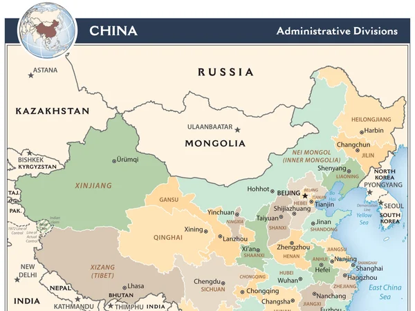
Administrative type: autonomous region. Capital: Urumqi.
Xinjiang is China's largest provincial-level region, covering roughly one-sixth of the country. Its scale includes the Tian Shan range, the Junggar and Tarim basins, the Taklamakan Desert and long international frontiers. “Visit Xinjiang” is therefore not one compact itinerary: Urumqi and Turpan form one practical cluster, Ili and Kanas another, while Kashgar and the Pamir approaches belong to a separate western route. A map can make these places look adjacent when overland transfers take most of a day. Choose one or two subregions, allow recovery time after long drives and compare seasonal road or flight conditions before committing to a circuit. Northern lake and grassland seasons do not match the best periods for desert-edge cities, and high mountain routes can change with weather. The Tian Shan image represents only one of Xinjiang's major landscapes. It should not be read as a portrait of the whole region or of its many communities. Check current official access notices for border and high-altitude areas, and approach neighbourhoods, markets and religious places as lived spaces rather than staged attractions.
Regional planning: Xinjiang Tours
The eastern Tian Shan landscape shows the mountain-and-basin geography that divides Xinjiang into distinct travel regions.
Administrative type: autonomous region. Capital: Lhasa.
The Tibet Autonomous Region is the second-largest provincial-level region. Much of it lies on the Tibetan Plateau, where altitude, distance and weather shape a journey more strongly than straight-line mileage. Lhasa, Shigatse, the central valleys, the Nyingchi area and far-western routes are not interchangeable day trips. A responsible plan builds in gradual acclimatisation, conservative drive times and contingency days instead of racing between map pins.
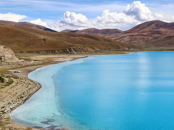
Yamdrok Lake illustrates the high-plateau setting, but a single lake view cannot represent the region's cultural or physical diversity. Monasteries and pilgrimage places remain active religious environments. Dress and photograph respectfully, follow local instructions and verify current entry, permit and route requirements through official channels and a qualified operator before travel; those requirements can change.
Regional planning: Tibet Tours
Yamdrok Lake sits within the high plateau environment of the Tibet Autonomous Region, where altitude and distance require measured planning.
Administrative type: autonomous region. Capital: Hohhot.
Inner Mongolia stretches in a long arc across northern China and is almost as large as Tibet. Its eastern forests and Hulunbuir grasslands, central cities around Hohhot and Baotou, and western deserts near Alxa are separated by very long distances. The region cannot be planned as one “grassland excursion,” and Hohhot is not a gateway to every landscape shown on a provincial map.
For a first trip, pick an eastern, central or western focus. Grassland access, grazing conditions and road quality vary by season; desert routes need different clothing, sun protection and contingency planning. Tourism takes place in working pastoral landscapes, so use established tracks, do not approach animals or private camps without permission, and avoid reducing Mongolian culture to costumes or staged horse-riding.
Regional planning: Inner Mongolia Tours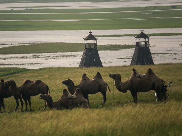
Camels and wet grassland in Hulunbuir show one eastern landscape within Inner Mongolia's much wider east–west span.
Administrative type: province. Capital: Xining.
Qinghai is the largest province in this ranking after the three autonomous regions above it. The northeastern Xining–Qinghai Lake corridor is the most accessible introduction, while the Qaidam Basin, Yushu and Sanjiangyuan areas involve much longer distances and higher, more remote terrain. Qinghai Lake is an important visual reference, but the province also includes salt basins, headwater landscapes, farming valleys and urban centres.
Altitude rises quickly outside Xining. Keep the first days light, carry layers for strong temperature changes and do not assume a bus timetable or road condition seen in an old guide still applies. Wetlands, lake shores and protected areas are ecologically sensitive; remain on designated routes and use the current local notice for seasonal closures.
Regional planning: Qinghai Tours
Qinghai Lake is a practical first reference point, while much of the province extends into higher and more remote plateau country.
Administrative type: province. Capital: Chengdu.
Sichuan spans the densely settled Sichuan Basin and the high mountains and plateaus of the west. That contrast is more useful to travellers than the area ranking alone. Chengdu, Leshan and the eastern basin can form a compact rail-based route; western destinations in Aba or Garze require separate time for mountain roads, altitude and weather. Jiuzhaigou, Mount Emei and a western Sichuan valley should not be squeezed into one unrealistic loop.
Start by deciding whether the trip is city-and-basin focused or mountain focused. If combining both, place Chengdu first and add buffer time before flights or trains home. In highland communities and religious sites, follow local etiquette and avoid treating minority areas as scenic decoration. Natural-area reservations, road controls and operating seasons should be checked at the responsible attraction or transport authority.
Regional planning: Area: about 486,000 km². · Sichuan Tours
A mountain settlement in western Sichuan shows how different the province becomes beyond the low-lying Chengdu basin.
Administrative type: province. Capital: Harbin.
Heilongjiang is China's northeasternmost province and ranks sixth by administrative area. Harbin's urban architecture and winter events are only one part of it; the province also includes the Greater and Lesser Khingan ranges, Amur and Ussuri river systems, wetlands, agricultural plains and forest towns. Mohe, Heihe, Yichun and the eastern border region sit far apart, so they need separate transport plans.
Winter can be the signature season, but it brings real cold, short daylight and weather disruption. Summer and early autumn give different access to forests and wetlands. Dress for conditions rather than photographs, keep batteries and phones protected in severe cold, and check official border-area or protected-area notices. The forest image here is a regional example, not a suggestion that all of Heilongjiang looks the same.
Regional planning: Heilongjiang Tours

A forest stream in Heilongjiang represents the wooded north of a province that also contains cities, wetlands and broad agricultural plains.
Administrative type: province. Capital: Lanzhou.
Gansu's narrow east–west shape follows the Hexi Corridor and connects very different landscapes: Lanzhou and the Yellow River valley, the Tibetan Plateau margin in the south, Zhangye's layered landforms, Jiayuguan and the desert-edge heritage around Dunhuang. The usual Lanzhou–Zhangye–Jiayuguan–Dunhuang route is logical, but it still covers hundreds of kilometres and should be built around train times rather than a string of same-day transfers.
The area range above is deliberate, not a typographical uncertainty. It tells readers that administrative statistics have methods and dates. For travel, the exact total matters less than the corridor geography, seasonal heat and cold, and reservation rules at heritage sites. Keep desert paths and danxia viewing areas clean and stay behind barriers protecting fragile surfaces.
Regional planning: Gansu Tours

Zhangye's layered danxia hills are one stop on Gansu's long Hexi Corridor rather than a stand-in for the entire province.
Administrative type: province. Capital: Kunming.
changes sharply with elevation and latitude. Kunming, Dali and Lijiang form a familiar northwest-facing route, but Shangri-La is higher and colder, while Xishuangbanna in the south is tropical and belongs to a different itinerary. The east also has major landscapes and towns that disappear from the standard circuit. A province this varied cannot be summarised by “spring weather” or a single old-town photograph.
Match clothing and pacing to the subregion. Mountain roads can be slow; altitude affects northwestern extensions; and rain changes trail and road conditions. Rice terraces are working agricultural landscapes as well as celebrated viewpoints. Use designated paths, avoid entering fields, ask before close portraits and learn the specific community and place name rather than describing all of Yunnan's ethnic groups as one tourism category.
Regional planning: Area: about 394,100 km². Yunnan overview · Yunnan Tours
Terraced fields in Yunnan reflect a cultivated mountain landscape shaped by water, elevation and local farming knowledge.
Administrative type: autonomous region. Capital: Nanning.
is widely pictured through the Li River and Yangshuo's karst peaks, yet the autonomous region also includes Nanning, the Beibu Gulf coast, Detian Waterfall, river valleys and communities across a broad border landscape. Guilin and Yangshuo work well as one compact cluster; Beihai or western Guangxi requires a separate transport plan. Nanning is the administrative capital, while Guilin is the better-known tourism gateway—those roles should not be confused.
Karst weather can obscure views and make stone paths slippery, but mist is part of the landscape rather than a failed visit. Use licensed boats or marked trails, keep distance from cultivated fields and verify cross-border-area access near the frontier. When visiting villages, name the place and community accurately and seek consent for portraits instead of using the broad label “minority village” as a description.
Regional planning: Area: about 237,600 km². Guangxi overview · Guangxi Tours
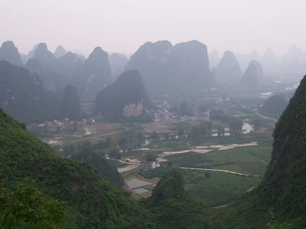
Karst hills near Yangshuo represent Guangxi's best-known landscape, while the autonomous region extends well beyond the Guilin area.
Administrative type: province. Capital: Changsha.
Area: about 211,800 km².
Hunan's tenth-place area still covers several distinct trip regions. Changsha and nearby heritage sites sit in the east; Zhangjiajie and the Wuling mountain area lie in the northwest; Fenghuang is farther southwest; and Dongting Lake shapes the north. High-speed rail shortens some journeys, but a map can still understate transfers between scenic districts, stations and mountain entrances. Northwestern Hunan is represented here by Zhangjiajie's sandstone pillars. Those formations are only one part of the province and should not eclipse Changsha's urban history, lake environments or everyday communities. At mountain sites, stairs, lifts, buses and weather all affect the usable route. Build a conservative walking plan, carry rain protection and check current ticketing and shuttle arrangements rather than relying on an old screenshot. Hunan is a useful reminder that “tenth largest” does not mean small in practical travel terms. A focused Changsha-plus-Zhangjiajie trip is usually more coherent than adding Fenghuang and Dongting Lake without extra days. Respect trail closures and viewing barriers, and avoid making universal claims about Hunan cuisine or culture from one meal or neighbourhood.
Regional planning: Dongting Lake and Yangtze context · Hunan overview · Hunan Tours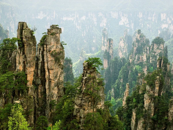
Zhangjiajie's sandstone pillars show the steep terrain of northwestern Hunan, one of several distinct landscapes in the province.
Editorial accountability
Hu Lei, CEO. The named owner is responsible for travel-planning accuracy and escalation of time-sensitive checks.
Yuntian Travel (Yunnan) Group is identified in its corporate profile as a licensed professional inbound travel service provider based in Kunming, China. Registration and travel-service documents can be requested before booking.
Page-specific references where cited, official destination, transport and entry notices, YUNSKY route-planning records, and direct provider confirmation before a booking is finalized.
Content is reviewed when rules, transport, access, pricing or route conditions change. Final availability and operating details are reconfirmed for each traveler’s dates.
Quality review: Page updated: