China's
Special Economic Zones China's special economic zones are best understood as bounded reform experiments, not a single template copied from city to city. In August 1980, the National People's Congress approved regulations for zones in Shenzhen, Zhuhai and Shantou in Guangdong; Xiamen in Fujian formed part of the same first group. Hainan became an island-wide special economic zone in 1988. Together, these are the five classic SEZs named in official national accounts. They helped test approaches to foreign investment, trade, land use and enterprise management before selected practices moved into wider national policy. That institutional story is one chapter in the broader
guide to China's economy, not a promise that every zone offers the same rules or outcomes today.
The five classic SEZs Shenzhen, Zhuhai, Shantou, Xiamen and Hainan are the five places covered here as special economic zones. Kashgar appears in a separate final section because official Xinjiang sources identify it as a national-level economic development zone approved in 2010. That distinction matters: a special economic zone, a free trade zone, a free trade port and an economic development zone are different policy categories, even when their goals overlap. Boundaries and operating rules also change over time. Travellers can use this page to understand the urban history visible on the ground; anyone making a legal, tax or investment decision should check the latest national and local government documents rather than relying on a travel guide.
Shenzhen: The First-Generation Test Ground
Shenzhen sits in southern
Guangdong. The city is the clearest place to see how an SEZ changed scale. The Guangdong regulations adopted on August 26, 1980 established the legal framework for the first zones, and Shenzhen's initial boundary covered only part of today's municipality. In July 2010, the SEZ boundary was extended citywide. The change did not turn Shenzhen into a finished model; it marked decades of experimentation, infrastructure building and integration with national and global supply chains. For a more comparative reading of the country's urban system, see the guide to
China's economic centers.
Guangzhou and
Hong Kong frame Shenzhen's regional context, but the city has its own geography and identity. Futian is the contemporary civic and financial core; Luohu retains border-era commercial layers; Shekou records an early industrial and port-led experiment; and Nanshan is closely associated with technology firms and university-linked research. These districts should not be treated as interchangeable skyline stops. Travelling between them reveals how planning, manufacturing, housing and public space developed at different moments.
The most useful historical evidence is often modest. At the Shenzhen Museum of Contemporary Art and Urban Planning or other municipal exhibitions, look for maps showing the former SEZ boundary and the fishing settlements, transport corridors and industrial estates that preceded today's towers. In Shekou, port infrastructure and later cultural reuse offer another lens. Exhibition names, opening hours and reservation rules can change, so verify the current venue notice before setting out.
Shenzhen is also a working metropolis, not a theme park about reform. Long commutes, neighbourhood markets, urban villages, waterfront parks and manufacturing-linked districts are part of the same story as headquarters and landmark towers. Avoid using a single observation deck to stand in for the whole city. A half day in central Futian plus a separate visit to Shekou or an older Luohu neighbourhood produces a more honest comparison.
What to notice: changing SEZ boundaries, links between ports and industry, the contrast between planned civic axes and dense mixed-use neighbourhoods, and the language local museums use to describe reform. These details make Shenzhen more legible than a list of growth statistics, which date quickly and rarely explain what a traveller can actually see.
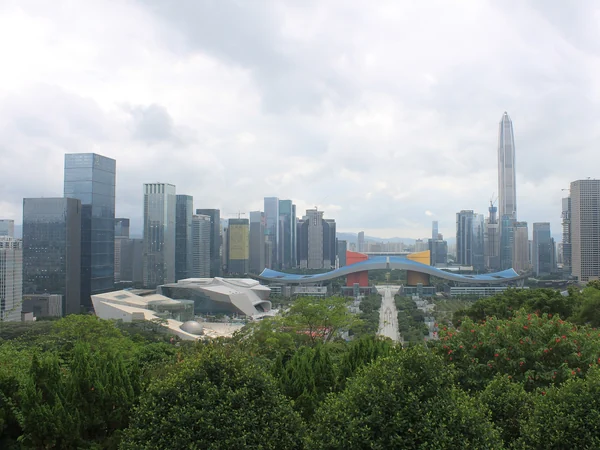
Futian's skyline shows the civic and commercial scale of present-day Shenzhen; the city's SEZ history extends well beyond its towers.
Zhuhai: A Coastal SEZ Beside Macao
Zhuhai was one of the first Guangdong special economic zones approved in 1980. Its position on the western side of the Pearl River estuary, immediately beside Macao, shaped a development path different from Shenzhen's. Islands, a long coastline and a more dispersed urban form are central to the city's character. The familiar seafront image of the Fisher Girl statue belongs to a civic landscape planned around Xianglu Bay; it is a symbol of Zhuhai, not evidence of the SEZ policy by itself.
Pearl River Delta connections matter here. Ports and cross-boundary transport link Zhuhai with Macao, Hong Kong and other mainland cities, while local districts have distinct functions and histories. Gongbei is a busy gateway; Xiangzhou contains the established urban centre; Hengqin is associated with later cooperation and development policies. Do not collapse Hengqin's current arrangements into the original 1980 SEZ story—they belong to related but later policy layers.
For travellers, the best reading comes from pairing the seafront with one piece of regional context. Walk a section of Lovers' Road, then visit a municipal museum or planning display if it is open. From there, compare the compact border environment near Gongbei with the quieter bays and islands. Weather can make exposed coastal routes uncomfortable, and border crossings are controlled travel points, so check transport, entry documents and opening information on official channels before the day of travel.
The Fisher Girl statue at Xianglu Bay is Zhuhai's best-known coastal landmark, set within a city whose SEZ history began in 1980.
Xiamen: From Huli to an Island-Wide Zone
Xiamen became one of the first four SEZs in 1980. The original zone was a 2.5-square-kilometre area at Huli, a far smaller footprint than the city visitors experience today. In 1984, the zone expanded across Xiamen Island. Those dates help correct a common misconception: Xiamen was not designated as one uniform modern city from the outset. Its reform history developed alongside an older maritime port, overseas Chinese connections and long-settled communities.
The city's bridges, port areas and rail links now make movement relatively straightforward, but geography still matters. Xiamen Island contains the historic urban core and many well-known sights; Jimei and Haicang offer different educational, industrial and waterfront contexts across the water. Build an itinerary around districts rather than zigzagging between isolated photo stops, and confirm ferry rules before visiting Gulangyu.
Gulangyu is valuable here precisely because it predates the SEZ. Its international-settlement-era streets, gardens and varied architecture form a UNESCO-listed historic urban landscape. Read it as evidence of Xiamen's earlier maritime history, not as an SEZ project. Back on the main island, Huli provides the contrasting reform-era geography. This before-and-after comparison gives the city more depth than the usual shorthand of beaches and cafes.
Useful stops combine Gulangyu's historic streets, a look at Huli's original-zone context and one local museum or waterfront walk. Ticket quotas, ferry terminals and visitor routes can change; use the operator's current notice rather than an undated blog.
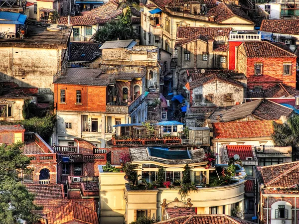
Gulangyu's dense historic neighbourhood records Xiamen's maritime past, which long predates the city's 1980 SEZ designation.
Shantou: An Older Port and a Less-Discussed SEZ
Shantou is often omitted from casual accounts of China's SEZs, yet it belonged to the original 1980 group. Its experience differed from Shenzhen's: the city had a nineteenth-century treaty-port history, strong links with overseas Chaoshan communities and a smaller initial zone. Official local history records an early 1.6-square-kilometre area at Longhu, followed by several boundary expansions; in 2011 the SEZ framework was extended across the municipality.
Shantou therefore rewards a layered reading. The old port district and surviving arcaded streets show a commercial city that existed before SEZ policy. Longhu and later development areas show a different planning era. Neither layer should be described as the sole explanation for the city's economy, and Shenzhen's trajectory is a poor benchmark for judging it. Comparison, not ranking
is the more useful approach. Shantou's location in eastern Guangdong, its Chaoshan cultural region and its diaspora networks created different constraints and connections from the Pearl River estuary zones. The country's major business cities form another category again; commercial importance and SEZ status are not synonyms. Plan a visit around the historic small-park and old-port area, then add a museum or a newer district if time allows. Arcades, warehouses, street patterns and food traditions make the development story tangible without leaning on volatile GDP figures. Some old buildings remain in active neighbourhoods rather than curated attractions, so photograph people and homes with restraint and follow any local access notices.
Hainan: Island-Wide SEZ and Free Trade Port
Hainan became a province and China's largest special economic zone in April 1988. Hainan is different from the four city-based SEZs because its designation covers an island province. In 2020, the central authorities released a master plan for the Hainan Free Trade Port, adding a newer policy layer to the older SEZ framework. Island-wide special customs operations began on December 18, 2025. These terms describe institutional arrangements, not an assurance that every purchase, business or traveller receives the same treatment.
Its scale makes neat summaries risky. Haikou, Sanya, Yangpu, Bo'ao, inland towns and rural landscapes play very different roles. Tourism is prominent, but ports, agriculture, services, conservation and local communities also shape the island. A visitor who sees only a resort coast will miss much of the province's social and economic geography. Haikou
is the provincial capital and a practical starting point for this history. Its arcaded qilou streets reflect older maritime commerce, while newer waterfronts and administrative districts belong to later urban growth. Sanya's resort landscape tells a different story, and Yangpu's port-industrial setting offers another. Allow travel time: Hainan is an island province, not a single compact beach city.

Haikou's Century Bridge crosses the Haidian River in Hainan's provincial capital, one urban setting within the island-wide SEZ.
Kashgar Economic Development Zone: A Terminology Note
In May 2010, the State Council approved a national-level economic development zone in
Kashgar. Official Xinjiang sources use the name Kashgar Economic Development Zone. Although English-language summaries sometimes call Kashgar a “special economic zone,” it is more accurate to distinguish its formal designation from the five classic SEZs. The policy context also differs: Kashgar is an oasis city in southern Xinjiang, far from the coastal locations of Shenzhen, Zhuhai, Shantou and Xiamen.
Kashgar has long been connected with routes across Central and South Asia, but the familiar phrase “Silk Road crossroads” should not flatten its history into a tourist slogan. The city's markets, mosques, neighbourhoods and languages reflect many periods and communities. The 2010 development zone is a contemporary administrative project; it did not create Kashgar's trading history, and the old city is not a visual illustration of current development-zone policy. Official designation matters because it sets the factual boundary of the page. Government material describes a national-level economic development zone approved in 2010, while the national statistical account identifies five classic SEZs elsewhere. Current plans, incentives and access conditions can change. This travel guide therefore explains terminology and visible urban context but does not offer legal or investment advice. A careful visitor framework
starts with contemporary life rather than a frozen image of the past. Kashgar's old-city streets include homes, shops and places of worship. Ask before making close portraits, do not enter private courtyards without invitation and follow posted rules at religious sites. Avoid describing neighbourhood residents as exhibits or using architecture to make sweeping claims about an entire ethnic community.
A street in Kashgar's old city shows a lived urban neighbourhood; it should not be treated as a stand-in for the modern economic development zone.