Your China & Yunnan Travel Experts


Dongchuan Red Land photography guide Reviewed August 28, 2026. Dongchuan Red Land is a highland farming landscape north of Kunming, not a single fenced viewpoint or a permanently red scenic field. Its visual pattern comes from cultivated plots, exposed red soil, crops, ridges, villages and changing light. Planting, harvest, rain and each household's work alter the colour from week to week, so use the Kunming travel hub for regional planning and ask a local host to confirm current road and field conditions shortly before departure. Older guides quote precise distance, altitude and colour superlatives without a traceable survey; treat those figures as orientation, not a guarantee.
When is the best time for Dongchuan Red Land photography?
There is no single best month. Late spring can combine newly exposed soil with young crops; summer may bring saturated colour, fast cloud and higher rain risk; autumn often gives harvest textures and replanted green strips; winter can be drier and more graphic but dawn is cold. Crop rotation means a famous multicolour view may be brown, green or recently ploughed on your date. Choose the story first—field geometry, agricultural work, storm light or a sunrise village—then build two sessions around it. Dongchuan photography timing Check the National Meteorological Center forecast and active warnings the evening before and again before leaving. East-facing and west-facing slopes respond differently to cloud, and a clear weather icon does not promise an open horizon. In the wet season, continuous rain can affect mountain roads and landslide or debris-flow risk; never ask a driver to continue through a closure for a photograph.
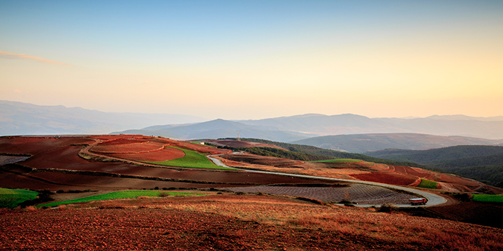
Cultivated red fields and crop patterns in Dongchuan's mountain landscape
Damakan is commonly used for a broad view of fields, settlement and layered hills, but it is not a reserved sunrise platform. Ask where visitors may stand without entering crops, arrive with a headlamp, and scout the final approach in daylight if possible. Start early enough for blue hour rather than assuming a fixed 5:00 arrival; sunrise time changes by season. Use a medium focal length to separate field bands, expose for the bright sky, and make a second frame after direct light reaches the land. Smoke or mist may occur, but neither is guaranteed and neither should be fabricated in editing.

Early light over Damakan village and surrounding red-soil fields
Luoxiagou, Jinxiuyuan, Yuepuao and Wafang Liangzi offer different relationships between fields, villages and distant ridges. Do not drive between all four during one sunset. Select a primary point after checking sun direction, cloud and legal parking, then name one nearby fallback. Keep the vehicle completely off farm access and public traffic lanes; road-edge viewpoints can become unsafe when visitors crowd the same bend.
Luoxiagou is useful when oblique light separates the basin's slopes and agricultural layers. The name ‘Sunset Valley' does not mean sunset occurs at a fixed 16:00–17:00 window; use the date-specific sun time and allow for the ridge to block direct light earlier. A short telephoto lens can reduce empty foreground and organize distant plots. If haze removes the layers, work on nearby texture instead of overprocessing contrast or stepping beyond the safe public edge.

Layered fields and village in Luoxiagou at Dongchuan Red Land
Jinxiuyuan offers a wide relationship between cultivated slopes and villages. Qicaipo is often translated as Seven-Colour Slope, but the number and colour of visible bands depend on what farmers planted and recently harvested. Compose with two or three dominant shapes, wait for side light, and record the date and crop state in the caption. Do not intensify individual fields until the image suggests a pattern that was not present.
Yuepuao works well for partial landscapes in which furrows and curved plot boundaries create rhythm. A 70–200 mm equivalent can isolate those layers; heat shimmer and wind may limit long focal lengths, so compare a wider frame before changing lenses. Houses, people and livestock can establish scale, but identifiable residents require consent and agricultural work should never be staged or interrupted.
Wafang Liangzi can connect nearby ridges, roads and field systems in one establishing image when visibility is good. Its higher roadside position also increases exposure to wind and traffic. Keep tripod legs inside a safe standing area, use the strap when moving, and leave before darkness makes the road edge difficult to judge. Luosiwan is a separate curved-road and field subject rather than a guaranteed sunset stop. Photograph the road only from a safe, legal position and do not stand in the carriageway or direct vehicles. A long lens can show the curve without encouraging an unsafe overhead or roadside angle.
Across all viewpoints, the fields are productive land. Stay on public paths, close no gates, pick no crops, and obtain permission before entering a terrace. Payment for a local guide or agreed access does not transfer control of neighbouring plots; confirm exactly where that permission applies.
Do not rely on an old instruction to take a Kunming–Fazhe bus and ask to be dropped at ‘Red Land.' Coach stations, stops and last-mile vehicles can change, while the viewpoints are dispersed. Verify the departure station, destination in Chinese, operating date, luggage rules, final connection and return before travel. Public transport can suit a flexible daylight visit, but it is a weak basis for sunrise unless lodging and a prearranged local transfer are confirmed.
For photography, a licensed car and driver usually make the scattered viewpoints more practical. Specify pickup, legal parking, the primary and fallback viewpoints, waiting time, return after dark, seat belts, price and weather cancellation. A driver or guide can help interpret access, but cannot promise colour, crops, sunrise or permission to enter private land. Drones require current registration, airspace compliance and local consent; keep one grounded if any requirement is unclear.
Choose accommodation by verified travel time to the first legal viewpoint, not by a claim that one village is always ‘central.' Huashitou, Luoxiagou and other settlements may have small guesthouses, but inventory, heating, hot water, meals and card acceptance vary. Confirm the exact property pin, road access, early-breakfast arrangement, driver parking and cancellation directly. Keep a screenshot of the Chinese address for arrival after dark.
Dawn and exposed ridges can feel much colder than daytime Kunming. Bring windproof layers, sun protection, water, grippy footwear, a headlamp, rain cover, lens cloth, spare batteries and two memory cards. Altitude varies across the area; pace climbs and tell the guide about relevant health conditions. If wind, lightning, dense fog or a road warning develops, switch to sheltered village details or stop. Protect people and equipment before protecting the schedule.
For one day, choose either sunrise plus a mid-morning field study or an afternoon scout plus sunset; driving every named point produces repeated views and poor safety margins. For two days, use Day 1 to scout, photograph one sunset and back up files, then use Day 2 for one conditional sunrise and a different focal-length study. The broader Yunnan travel guide helps place Dongchuan in a longer regional route without pretending it is a quick Kunming city excursion.

Dongchuan Red Land route brief
From $ 1568
From $ 850
From $ 2583
Editorial accountability
Hu Lei, CEO. The named owner is responsible for travel-planning accuracy and escalation of time-sensitive checks.
Yuntian Travel (Yunnan) Group is identified in its corporate profile as a licensed professional inbound travel service provider based in Kunming, China. Registration and travel-service documents can be requested before booking.
Page-specific references where cited, official destination, transport and entry notices, YUNSKY route-planning records, and direct provider confirmation before a booking is finalized.
Content is reviewed when rules, transport, access, pricing or route conditions change. Final availability and operating details are reconfirmed for each traveler’s dates.
Quality review: Page updated: