Your China & Yunnan Travel Experts


Xianggong Hill and Cuiping Hill photography guide—reviewed August 28, 2026. These are two separate rural karst viewpoints in Yangshuo County with different light assignments: Xianggong is generally planned for dawn over the Li River corridor, while Cuiping is generally planned for late light across fields and peak forest. Use the Guilin travel guide for regional orientation, then reconfirm each entrance, opening time, road condition, ticket, platform and tripod rule for the shooting date. Sunrise, cloud seas and a clear sunset are weather outcomes, never inclusions that a guide or ticket can guarantee.
Xianggong Hill rises near the Li River landscape between Xingping and Yangdi. The broader Guilin Karst is an inscribed component of UNESCO's South China Karst, but that designation should not be stretched into a claim that every private path, viewpoint or nearby village is separately listed. A useful picture explains the relationship among tower karst, river bends, valleys and weather rather than treating the peaks as a generic backdrop. Scout the legal platform in daylight when possible, save the Chinese place name and pickup point offline, and ask whether construction, vegetation, crowd control or seasonal access has changed the familiar composition.
The old page relied on a film-festival anecdote to establish authority. A stronger assignment starts with observable evidence: direction of first light, cloud base, haze, wind, river visibility and crowd density. Make one wide geographic frame, one moderate-telephoto study of overlapping peaks and one detail that includes the Li River or village scale. Record time, focal length, direction and visibility in the caption notes. Do not call mist a “sea of clouds” when it only obscures the valley, and do not remove villages, roads or modern river traffic merely to manufacture an untouched landscape.
May to October can offer humid dawn atmosphere, yet a useful Xianggong visit is not restricted to those months. Winter may bring clearer layers; spring can be wet and foggy; summer heat and storms can affect roads and visibility. Compare a current local forecast with the Li River seasonal guide, then check again the previous evening and before departure. Ask for the actual remaining stair count and walking time rather than relying on the inherited 20–30 minute estimate. Carry a headlamp, water, lens cloth, fitted rain cover and footwear with grip. On wet stairs, keep one hand free, yield to descending visitors and choose a stable rail-side position without blocking the route.
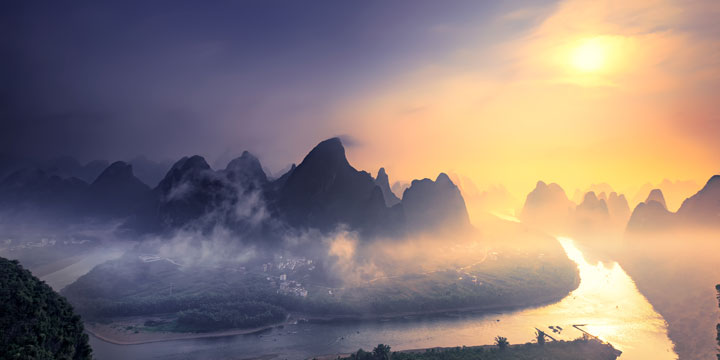
Morning karst panorama from Xianggong Hill above the Li River
Xianggong is a predawn road-and-stair assignment, so route certainty matters more than the nominal distance. Confirm the correct entrance, vehicle drop point, driver contact, gate time, return plan and mobile coverage in writing. Road works, village traffic and local vehicle controls can change the final approach. Build a weather cancellation rule before paying a non-refundable predawn transfer, and keep enough time to descend in daylight rather than rushing to another attraction.
1. A licensed private transfer from Guilin or Yangshuo is the most controllable dawn option for people carrying tripods or long lenses. Confirm seat belts, luggage space, pickup time, overtime terms and whether the driver waits at the same entrance. A private car provides transport, not permission to enter before opening, stop on a blind bend or use a restricted path.
2. Public buses toward Putao, Baisha or nearby towns may be useful in daylight, but routes, boarding points and last services change. Verify the operating station and final connection shortly before travel; do not build a sunrise plan around an old timetable. From the public drop point, use a locally authorized onward vehicle and confirm the fare and exact return pickup before setting out.
3. Yangshuo Railway Station is near Xingping rather than central Yangshuo. A train can support an afternoon scout or an overnight Xingping base, but a same-morning arrival normally does not solve the predawn gate and final-road problem. Confirm the station transfer separately and allow for luggage, darkness and the climb; the place name “Yangshuo” should not be treated as proof that every viewpoint is nearby.
4. River transport or a bamboo raft should be treated as a separate Li River experience, not a dependable access promise for Xianggong. Operating sections, water level, weather, passenger restrictions and landing points can change, and an informal landing does not authorize a hillside shortcut. If a river segment is important, use a current licensed operator and keep a road-based alternative.
Xianggong and Cuiping should not be presented as interchangeable. At Cuiping, the main visual subject is the relationship among karst peaks, cultivated plots, ponds, orchards, roads and villages under late light. Arrive early enough to understand which slopes receive side light and which foregrounds are active farmland. If high cloud blocks direct sun, photograph land-use layers and softer colour rather than forcing an orange sunset in editing. Keep one frame before golden hour as an honest geographic reference.
Cuiping Hill is west of Cuiping Village near Putao. The older copy called the hill itself “nominated by World Natural Heritage,” which is not a reliable heritage category. The accurate boundary is that the region belongs to the wider Yangshuo–Guilin karst landscape; current official interpretation should determine whether a named site falls inside a specific protected component or buffer. Do not use UNESCO language to imply unrestricted access, guaranteed conservation status for a private trail or ownership of a view.
From a legal high position, use a normal lens to connect fields and settlement with the peaks, then a short telephoto to simplify repeating ridges. A polarizer can deepen haze unevenly and remove useful reflection from ponds, so rotate it while watching the whole frame and make a reference without it. Protect the brightest cloud edge, expose to retain field texture and avoid pushing greens or orange light beyond what the scene contained. People working below are not decorative scale markers; use a long lens only from public ground and seek consent for any identifiable portrait.
Cuiping is a living agricultural setting. Stay off planted plots, bunds, irrigation edges and private courtyards, even when a geotag suggests a shortcut. Do not move tools, ask a farmer to pause work or fly over homes. Drones require national compliance plus explicit local, land, scenic-area and privacy permission; wind around karst peaks and a crowded summit add operational risk, so ground photography is the default. Leave before the descent becomes unsafe, and carry a headlamp even when the plan is to finish at sunset.
Confirm the correct Cuiping or Wuzhishan entrance because similar translated place names can point to different roads. Ask for current ticketing, vehicle access, parking, closing time, final stair or trail condition and sunset descent rules. Save the driver's phone number and the entrance pin in Chinese; mountain lanes can be dark and mobile coverage uneven.
1. A licensed transfer from Guilin or Yangshuo allows a daylight scout and a controlled return after sunset. Put the exact entrance, waiting time, luggage, total driving hours and cancellation terms in writing. The driver should use a legal pull-off and should never stop where the road is narrow simply because the view opens.
2. A bus toward Putao may reduce cost, but the last onward and return connections must be verified for the date. Public service is better suited to a daylight visit than a late sunset departure. If the final segment needs a local vehicle, agree on a named pickup location and a safe fallback before climbing.
Use day one for a daylight Xianggong scout or Li River context, then sleep near the confirmed dawn pickup. Photograph Xianggong on day two morning, back up files and rest at midday, and attempt Cuiping only if the forecast, road, legs and return plan remain suitable. Two low-light climbs in one day are optional, not a test of commitment; weather or fatigue should trigger a town, riverbank or countryside alternative. The Li River cruise route can provide geographic context on a separate day, but it should not be compressed between a predawn ascent and a sunset descent.
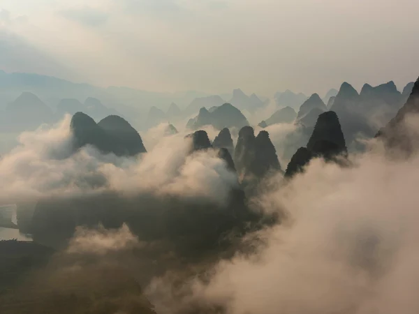
Xianggong and Cuiping photography route through the Guilin karst landscape
From $ 1568
From $ 850
From $ 2583
Editorial accountability
Hu Lei, CEO. The named owner is responsible for travel-planning accuracy and escalation of time-sensitive checks.
Yuntian Travel (Yunnan) Group is identified in its corporate profile as a licensed professional inbound travel service provider based in Kunming, China. Registration and travel-service documents can be requested before booking.
Page-specific references where cited, official destination, transport and entry notices, YUNSKY route-planning records, and direct provider confirmation before a booking is finalized.
Content is reviewed when rules, transport, access, pricing or route conditions change. Final availability and operating details are reconfirmed for each traveler’s dates.
Quality review: Page updated: