Your China & Yunnan Travel Experts


Xiapu photography guide—reviewed August 28, 2026. Xiapu County lies on the northeastern Fujian coast and is known for tidal flats, bays, islands and working aquaculture. Start with the Fujian travel guide, then treat the coast as an active production and wetland landscape rather than a collection of permanent props. Tide, wind, cloud, water clarity, sea-farm work, access and safety determine a shoot more than a fixed month list. Confirm legal viewpoints, current road or boardwalk status and the day's marine forecast before travelling.

The long, indented coastline creates many combinations of mudflat channels, bamboo or seaweed structures, boats, villages and reflected light, but the arrangement changes with aquaculture cycles and tide. A responsible image identifies the actual bay and activity instead of labelling every patterned flat “Xiapu fishermen.” Do not direct workers, enter a raft, walk onto mud, move farm gear or imply that a staged net-casting scene is spontaneous labour. Keep location, date, tide stage, lens direction and consent notes with the files.
Xiapu can be photographed year-round. Plan by subject first: sunrise or sunset direction, visible mudflat at a safe tide stage, active kelp or laver work, village or island context, or a weather-resilient cultural assignment. Obtain an official tide table for the nearest relevant port, then ask a knowledgeable local how that predicted height translates to the exact bay. Tide times shift daily and one headland can look different from another; never use the previous day's observation as a safety guarantee.

The name Xiapu is often translated poetically as “sunlit shore,” but the photographic value comes from observable coastal systems: tide channels, sediment, aquaculture frames, boats, villages, islands and human work. The province's current coastal tourism routes include developed public viewpoints and the Donghai No. 1 coastal route, yet opening, transport and operating details can change. Use signed facilities and a current local plan rather than copying a viral geotag. The following locations have distinct assignments and should not share the same caption.
Xiaohao is commonly planned for tidal patterns, reflected side or back light and aquaculture activity across a bay. The scene works only when tide, water surface, sun angle and work align. Arrive in daylight, locate the signed public position and watch one tide cycle if the schedule allows. Make an orientation frame that includes headland and village before isolating channels or figures with a long lens. Do not descend from a platform onto a slippery slope or working area.
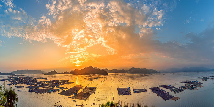
East- and west-facing positions can offer different light, but access and vegetation change. Ask which public viewpoint is open and what direction it faces on the date. A higher position compresses people and channels; it does not make the ground below public. Keep tripod legs within the platform footprint, use a strap in wind and leave a passing lane. If the useful light falls outside a safe position, change the composition rather than the boundary.
Tip 1 — arrive roughly 60–90 minutes before the predicted useful light, not automatically at 14:00. Confirm tide and sunset, scout a foreground, make a clean reference frame and decide the latest safe departure before the platform becomes dark or crowded.
Tip 2 — carry a normal zoom plus a controlled telephoto. Around 100–400 mm can isolate channels, boats and workers from a legal high position, but focal length should follow the subject. Use a faster shutter for boats or labour, stabilise the lens and leave room around people rather than compressing them into abstract dots.
Tip 3 — strong backlight can be edited when exposure is sound. Protect the brightest meaningful reflection, check each colour channel, bracket only a static scene and inspect moving boats or people before blending. Haze and flare are conditions to manage with position, hood and a clean lens—not reasons to invent detail in post-production.
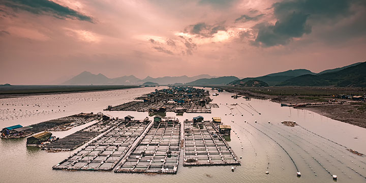
Beiqi is associated with sunrise-facing views of tidal textures, aquaculture poles, boats and working flats. Pattern visibility depends on water level and angle; low tide is not automatically best, because overly dry mud can lose reflection and a rising tide can cut off unsafe ground quickly. Observe only from the designated public edge or platform and keep the village access clear. A wide frame explains the bay; a telephoto frame can organise lines without turning workers into anonymous decoration.
The older text promoted a natural cliff edge as the best point. That is unsafe guidance. Use a signed maintained viewpoint, barrier or locally authorized public space, and never stand outside a rail to clear another tripod. Check wind and surface condition, lower the centre column, attach weight only if it cannot swing, and avoid opening a large umbrella in a crowded line.
Arrival time should be calculated from current sunrise, gate and walking time rather than fixed at 06:00. Scout before dark if possible. Begin with pre-dawn blue and shore geometry, then adapt as the tide reveals or covers channels. Protect bright reflections, use enough shutter speed for boats and inspect focus after spray or condensation. If a warning, barrier or crowd prevents the planned angle, use a shorter lens from farther back.
Dong'an is known for dense offshore aquaculture and floating or stilted structures viewed across the water. Describe these as a working sea-farm landscape, not an unqualified “Venice at Sea.” Confirm the exact lookout and what structures remain active, because layouts change. A moderate or long lens can layer rafts and channels; include open water or shoreline to preserve scale. Night lights may belong to production and navigation, so avoid assuming they are decorative and do not over-saturate them. Boat access requires a licensed operator, life jacket, safe weather and explicit permission for the working area.

Other assignments include Huazhu or nearby east-coast viewpoints for dawn, Dongbi for late light, Shajiang for harbour geometry, Yangjiaxi for river and tree landscapes, and Taimu Mountain for a separate mountain subject. Names and transliterations vary, so save the Chinese destination and confirm the actual entrance. Do not combine photographs from different bays under one location label. Dayushan Island also requires a current ferry and weather plan and should not be promised as a quick detour after a mainland sunset.
Xiapu's historic “eastern, southern, western and northern route” lists are useful for orientation but not fixed operating itineraries. Group nearby subjects only after checking tide, road, viewpoint, ferry and current aquaculture work. Base near the Xiapu Railway Station or county area when it reduces predawn transfers, but verify the actual hotel-to-viewpoint driving time, breakfast, luggage, late check-in and vehicle availability. Keep one low-light target per session and one weather-independent backup.

Pair one confirmed dawn viewpoint such as Huazhu or Beiqi with a midday scout and one late-light location such as Dongbi or Xiaohao. Do not attempt every named point on the same day. Traffic, parking and platform capacity can erase the time saved on a map; rest and file backup belong in the itinerary.
Best for : sunrise direction, patterned tidal flats, coastal villages and a separate late-light bay—provided tide, access and weather support those subjects.
Shatangli, Shajiang, Weijiang and Dong'an represent different mainland and offshore perspectives. Choose one primary subject, confirm whether the classic S-shaped harbour or fish-raft view remains visible from a public point, and budget transfer time. A long lens, sturdy support and haze-aware exposure are more useful than rushing between all four names.
Best for : harbour curves, aquaculture structures, boats and working-coast scale, with captions that identify the actual bay and activity.
Hanjiang, Beidou, Dajing, Wenqi and Chuanlu can involve beaches, settlements, sea-farm work and historic places, but conditions and opening status differ. Do not market the sequence as a guaranteed kelp harvest. Select locations by current activity and safe daylight transfer, and ask before photographing inside a community or workplace.
Best for : a mixed coast narrative rather than one sunset chase—working shore, village context, beach or architecture according to what is verifiably accessible.
Yantian, Nantang, Beixi, Qidu and nearby bays can support fishing-community and aquaculture stories. Use current spelling and local confirmation because online pins can conflict. Boat families and workers are people, not attractions: obtain consent for identifiable images, do not board without invitation and never publish a home or work location in a way that creates a privacy or safety risk.
Best for: sea-farm systems, shoreline engineering, boats and community context photographed from authorized ground or a properly licensed vessel.
Yangjiaxi and Taimu Mountain are separate from a classic tidal-flat sunrise. Allow a dedicated half or full day, confirm the correct gate and walking requirement, and do not promise seasonal foliage, shafts of light or mist. Mountain weather and slippery trails require a turnaround time; riverbank and tree scenes require care around roots, water and visitor paths.
Best for : trees, river, villages and granite mountain landscape—a useful weather and storytelling contrast to the coast rather than filler between two tidal sessions. For mudflat ecology and access context, read the Xiapu Mudflat guide. A practical three-night plan uses arrival afternoon for scouting, one dawn and one late-light coast session on the full day, a second dawn or working-coast assignment on day three, and a weather buffer before departure. Carry two lenses rather than changing glass in salt spray, clean gear each night, make two backups, and log location, tide, weather, permission and activity with every final image.
From $ 1568

From $ 850
From $ 2583
Editorial accountability
Hu Lei, CEO. The named owner is responsible for travel-planning accuracy and escalation of time-sensitive checks.
Yuntian Travel (Yunnan) Group is identified in its corporate profile as a licensed professional inbound travel service provider based in Kunming, China. Registration and travel-service documents can be requested before booking.
Page-specific references where cited, official destination, transport and entry notices, YUNSKY route-planning records, and direct provider confirmation before a booking is finalized.
Content is reviewed when rules, transport, access, pricing or route conditions change. Final availability and operating details are reconfirmed for each traveler’s dates.
Quality review: Page updated: